
Maiden cliffs - a great idea for a walk in the Rhodopes
- Stefan Ivanov

- May 2, 2023
- 10 min read
Updated: Jan 20, 2025
On the last day of April, the mountain calls me and I set off.

I choose the Rhodopes.
I went to a place known as "Momini skali", a.k.a. Maiden cliffs and as it turned out, this is a great idea for a walk in the Rhodopes.
The starting point for Maiden cliffs is the village of Izvor, hidden in the picturesque northern slopes of the mountain.

If you set the village to your navigation, as I did, it will take you directly to the starting position. For everyone else, I'll describe how to get here.
The starting point is the city of Plovdiv.
Take the road Plovdiv - Parvenets - Hrabrino.
Arriving in Hrabrino, in its center, before crossing the Pepelashka river on the wide bridge in the direction of the villages of Dedovo, Boykovo, Sitovo and Lilkovo, which fall to the right, turn left on "Vtora" street - this is a narrower road between the country houses.
Continue straight along the road (carefully and slowly, because it is narrow), as the street soon makes a big turn (almost 180°) and along it you leave the limits of Hrabrino.
The road winds straight, and on the left is the "First Villa Zone" - cute and new houses with tidy yards. From here to Izvor is less than a two-minute drive.
Entering Izvor, keep going straight until you reach a large square, on the right of which rises the white building of the town hall of the village of Izvor, Rodopi municipality.
Leave your car in the wide square in front of the town hall building, take a backpack with food and water with you. Put on comfortable high hiking boots and you're ready for adventure!

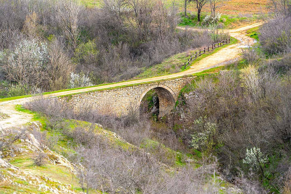
On the photo I have shown the starting point of the path to "Momini skali". This is the street to the left of the Izvor City Hall building.

To the right of the alley is a sign on a tree with the inscriptions "St. Elijah" and "Momini skali", which also tells the correct starting direction.

There is a red building in the yard of the Izvor town hall - it is the national community center "Lach - 1927", which I pass by.
I continue straight along this street and soon leave the village.

Little by little, the street turns into a wide path that winds on the outskirts of Izvor through the northern slopes of the beautiful Rhodopes.
Since it's the end of April, everything around is fresh green!
The trail is easy and almost uneventful. You walk on it confidently, calmly and without panting.
Due to the rains, large mud puddles have formed in places, but they are not many and are easily bypassed.

Almost the entire length of the path offers shade and direct exposure to the strong sun rays is kept to a minimum, which is also quite nice.

Important to note is that the trail is perfectly signposted and marked, so it's virtually impossible to go wrong. A wooden arrow-shaped signpost with the words "Lily Cliffs" engraved on it is laid out at each turnoff, so just follow the directions.

After about ten minutes of easy walking after the end of Izvor, I reach the first fountain along the path that falls to the left. A detour leads past it to the "St. Ilia" chapel, which is located very close by.
I continue straight as indicated on the signs on the right on the trees.


After another ten minutes of easy walking, the path leads me to a wide meadow. To the right of it, peculiar benches are formed, where you can sit and rest your legs.
The view of the northern slopes of the Rhodopes is enchanting – it soothes the soul, caresses the eyes and makes you smile.


Spring has gifted this land with extraordinary beauty! Everything around blooms in the most diverse forms and colors.
In the first photo moment, I have shown the so-called Monkey Salep*, also known as the "Monkey's Snout" orchid (Orchis simia), which at this time of the year is found all around and blooms superbly.
*This is a perennial herb with egg-shaped tubers and a stem height of about 24 to 45 centimeters. Basal leaves are ovate or ovate-lanceolate. Inflorescence - compact, egg-shaped, multi-colored. Perianth leaves are whitish, finely violet saturated, collected in a helmet. The lip is about 10 to 20 centimeters long, deeply three-lobed, pink-purple with purple dots. Side lobes – linear, very thin (about 1 millimeter). The middle lobe is linear, divided at the top into two linear lobes, between them with a small tooth. The spur is about 4 to 8 millimeters long, cylindrical, pointing downwards.
In the second photo moment, I have shown Umbrella Raven**, which has appeared in all the sunlit places.
**Umbrella crow's onion, also Crow's onion or Ornithogalum (Ornithogalum umbellatum) is a small, herbaceous, flowering plant that belongs to the Asparagus family (Asparagaceae). It is also known by the names: star of Bethlehem, grass lily, nap at noon, eleven o'clock lady. The genus to which it is classified is represented by about 100 species.

After about ten minutes, the white silhouette of the "Saint Archangel" chapel, built in 1926, emerges on the right of the path.

Directly opposite the chapel and along the path, you can rest on these benches and eat at the tables set up.
Cold mountain water gushes from the nearby fountain for thirsty throats.

Here the path makes a left turn past the second fountain.

After about ten minutes I reach a new fork, which is also perfectly marked, so it's practically impossible to go wrong.
The first of the three branches leads to the village of Hrabrino and the Chapel of the Holy Virgin, as described on the information signs pointing to the path.
The third fork is a path to the "Zdravets" hut.
I take the middle of the three forks, marked by the familiar wooden sign reading "Momini Skali".

Very soon the path narrows into a small path, but it continues to be easy and you walk along it with a song in your mouth.

After about five minutes of easy walking along the narrow path, I come to the first unmarked fork, which I have shown in the next photo moment.

Both the forks you see lead to the cliffs, from where a wonderful view is revealed! That's why I advise you to take both paths alternately!
The path to the left leads directly onto the rocks, from which a direct view of the opposite slopes of the Rhodopes, of the Pepelashka river in the valley and of a series of extremely picturesque rocks located opposite each other, is revealed.
The path on the right leads directly to the sheer cliffs and to a series of exceptional panoramic views of the village of Hrabrino (in the distance) and the opposite cliffs.
Consecutively - slowly and calmly go around all the paths and enjoy another wonderful Rhodope miracle!
In the following video, I have collected the best of the extraordinary sights that you will witness for yourself. This short (3 minute) film of mine will reveal to you the wonders that await you.
Enjoy!
Perfectly warmed and charged with beauty let's continue with my story.

I took the right fork in the trail and immediately came upon these fragrant lilac bushes blooming beautifully and smelling of pure joy!
In a minute I'm at the rocks, from where a majestic view strikes me!

The rocks are not secured and I advise you to be extremely careful!
The views from this place, both to the northern slopes of the Rhodopes, and to Hrabrino and the Thracian plain, are impressive, unique in their beauty and deeply affecting!

A light breeze moved the air, birds filled the sky with Rhodope songs, the sun smiled sweetly from the blue, white clouds rose from the mountain, and all this deeply touched my soul!


From here the path leads along the edge of the rocks in the direction of the cross laid on the rock in front of me.

This is a section with increased concentration and heightened attention!
The path to the cross winds along the edge of the rocks and I advise everyone to be extremely careful!

In minutes I'm already at the cross.

The place offers incredible and majestic views!

Looking south, the stunning panorama towards Hrabrino impresses any seeker of charm and magic!
I used optical zoom to try to capture the white silhouettes of red-roofed houses perched on the slopes of the Rhodopes.


Standing on the edge of the cliff, the view into the abyss reveals the thin silver strip of the Cinderella River, the same one we saw in the village of Hrabrino, with several beautiful water falls on the water, forming dizzying waterfalls.


The canyon of the Cinderella River is incredibly picturesque, impressively charming and extremely beautiful!
The green virgin centuries-old forests of the Rhodope Mountains descend almost to the river from the south, and the impenetrable Momini Rocks from the north complete the immense majesty of this magnificent canyon.
You can stay here for hours, losing yourself in beauty!
After you've had your fill of the sights, take the familiar path back and return to your starting position.
All along the cliffs, it is possible to access a number of unique panoramic platforms - places on the rocks around, from which you can admire the perfection of nature in its purest form.

I advise you to take your time, but carefully follow each tiny path and access as many wonderful and exceptional viewing spots as possible. I did so!

Who said that man-made things can't be beautiful!


The opposite slopes offer no less exciting views, complete with spectacular pyramids created by art bohemians.

Contemplating these astonishing and untouchable works of millions of years past, along with wind and water, I feel perfect, true and at one with the world around me like nowhere else!

All the videos I shot in this impressive and remarkable place, I put together in one wonderful movie of 16 minutes duration.
16 minutes of perfection in its purest and unadulterated form!
16 minutes of greatness of the Creator!
Momini skali - a great idea for a walk in the Rhodopes in 16 exceptional minutes!
Enjoy!
The return path to the village of Izvor is the same and is taken in one breath.
How do you get to the village of Hrabrino?
Hrabrino is a village in southern Bulgaria, in the Rodopi municipality, Plovdiv district.
The village of Hrabrino is located in a mountainous area, about 15 kilometers southwest of Plovdiv. Around the central, older part of the village, along the mountain ranges, there are two large, continuously growing villa areas. Two rivers pass through the village. From here, the tourist routes to the "Zdravets" hut, "Ravnishta" hut, the village of Boykovo and the "Akademik" hut (old name "Rhodopski partisans") located near the village, 4 kilometers away, start.
Bravely stand on:
155 kilometers (about 1 hour and 50 minutes by car) from the capital
15 kilometers (about 20 minutes by car) from the city of Plovdiv
392 kilometers (about 4 hours and 26 minutes by car) from the city of Varna
270 kilometers (about 2 hours and 38 minutes by car) from the city of Burgas
How do you get to the village of Izvor?
Izvor is a village in southern Bulgaria, in the Rodopi municipality, Plovdiv region and is located entirely in a mountainous area.
It is assumed that the village was founded by a population fleeing during the Turkish slavery, coming from the Macedonian part of Bulgaria. Until now, the natives speak a dialect characteristic of Macedonia - 'ke ida, 'ke doda.
There are families typical for this part of Bulgaria.
The original site of the village is further up the mountain, where even now there are ruins and walls of houses, as well as fruit trees.
There is also a road nearby that is covered with stone slabs, probably built by the Romans.
The village of Izvor is located less than 3 kilometers (less than 5 minutes) from the village of Hrabrino.
In the center of Hrabrino, before the wide bridge over the Pepelashka river, take "Vtora" street to the right.
Maiden cliffs Route
Type of route – need for transport to the starting point in the center of the village of Izvor and then entirely on foot.
Total length of the pedestrian section - about 4.5 kilometers (distance from the center of the village of Izvor to Momini skali - about 2.2 kilometers).
Duration – About an hour one way, depending on the pace you walk and also the number and length of breaks you take.
Appropriate equipment - comfortable sports shoes, as well as comfortable clothing and outerwear according to the season.
Difficulty of the route - the path to the rocks is for the most part completely easy, shady, without difficulties and with a very slight unevenness (in places).
Elevation:
in the center of the village of Izvor - about 540 meters above sea level.
at the first fountain - about 550 meters above sea level.
at the second fountain (at the "Saint Archangel" chapel) - about 550 meters above sea level.
at the rocks - about 570 meters above sea level.
The "Momini skali" route is recommended for people of all ages!
What can be visited nearby?
2.4 kilometers from Hrabrino (about 4 minutes by car) there is a beautiful artificial waterfall that I suggest you visit.

15.8 kilometers from Hrabrino (about 24 minutes by car) is the charming Sitovski waterfall.

About 16 kilometers from Hrabrino (about 20 minutes by car) is the town of Perushtitsa.
In Peruštitsa you can visit the Renaissance (Danovo) School.

Next to the school building is the church "St. Archangel Michael".

The Red Church is located at the exit of Peruštitsa in the direction of Joakim Gruevo.

19.5 kilometers from Hrabrino (about 25 minutes by car) is the village of Ustina.
In Ustina, take the Ustina eco-path to the Ustina waterfall.

And as a finale, my dear friends,
you shouldn't miss a look
the special album with photo moments –
discovered, experienced, captured and shared with you!


Comments