
Eco-path "Komin Dere" above Laki - a perfect idea for a walk in the Western Rhodopes, combined with amazing panoramic views
- Stefan Ivanov

- Jul 6, 2024
- 6 min read
Updated: Jan 17, 2025
The "Komin Dere" eco-path above the city of Laki is a great idea for any lover of easy walks in the wonderfully beautiful Western Rhodopes, combined with phenomenal panoramic views.

The walk along the eco-trail is really easy, very pleasant and suitable for any amateur traveler of any age.

And the culmination is the stunning panorama opening from the extreme point – the cliffs above the town of Lucky in all directions.
The trail starts from the town of Lucky – from its most northwestern point.

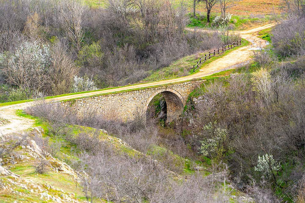
The trail is actually a narrow asphalt road, where it would be difficult for two cars to pass each other. That is why I advise you to leave your car in Lucky and embark on this journey on foot.

At its very beginning, the road makes a sharp right turn almost 360 degrees and leads past the westernmost houses of the city and the slopes of the mountain.

Lucky's pets were obviously used to strangers, because they paid us little attention as they lazily basked in the July sun.

Very soon you will reach the first goal, which is located about 350 meters from the starting point, and which will welcome you along the eco-trail – the Nazarova Fountain and a wooden gazebo.


Here you can relax, drink ice-cold mountain water from the four spouts of the fountain, and continue forward and upward with renewed strength.

The trail is generally easy, and the asphalt road is pleasant to walk on and almost tireless. The elevation gain is not great – at its starting point it is 706 meters (altitude), and at the top – at the three wooden huts it is 900 meters (altitude). The distance from the starting point to the end is about 2.5 kilometers in one direction.

Throughout the entire "climb" of the eco-trail, what will constantly accompany you are the endless, intertwined, green-blue Rhodope hills, which are so heavily indented that they deeply impress with their shape and strangeness.

The city of Lucky will gradually recede and its residential buildings will seem smaller and smaller to you - like houses from a children's Lego set.

The pearl in the crown of the Western Rhodopes - the emblematic peak Stanchov Kamak, which is part of the Perelik-Prespa section, will literally capture your attention with its inaccessible and harsh beauty at all times.

In general, the narrow asphalt road is almost always open and only in certain sections of the path are there any real shady spots, so if you have chosen summer for a walk, take the eco-trail in the earlier hours of the day to save yourself a "climb" under the hot summer sun.

Some for more time, some for less, we managed to "climb" the "Komin Dere" eco-trail in about an hour, stopping for rest as many times as we wanted.

About 30 minutes to an hour after you set off on the Komin Dere eco-trail, you will arrive at this blue arrow sign with a view from the rocks. Now is the time to leave the narrow asphalt road and head in the direction indicated by the sign.

I admit that at first it is a little daunting, because there is actually no road. You just have to take the grass between the large bushes in the direction indicated by the sign. Literally after a few minutes of climbing you will start to see the tops of the roofs of the three wooden gazebos, erected here by skillful Bulgarian hands. The distance from the fork with the arrow sign to the first wooden gazebo is about a hundred meters in a northeasterly direction.

We have arrived!

It's definitely time for a break!

And while you are properly resting amidst the shade and coolness in one of the three wooden gazebos, the views from their wooden windows captivate the senses, caress the gaze and make us gasp deeply in admiration!

Stanchov Kamak Peak is 1299 meters high and literally looms menacingly over Lucky.

I'm trying to capture the inaccessible rocky pinnacles of Stanchov Kamak with my camera. The peak is quite photogenic and I arranged a fitting photo session for it, wonderful photo moments from which I have prepared for all of you in the special photo album, a link to which you will traditionally find at the end of this post.

After you have properly rested and breathed in the beauty of Stanchov Kamak Peak, I suggest you slowly head towards the culmination of today's wonderful Rhodope walk.а.

Just looking at the photo above gives me goosebumps!

When I first stood facing this metal railing, enclosing rocks on two sides, at the bottom of which you can see a pylon on which the wind blows the Bulgarian tricolor, I trembled!

I remember every step perfectly – I walked slowly, step by step, and after each step, the adrenaline was noticeably rising in my body!

At the end of the path, not one, but two Bulgarian flags awaited me! Here, too, the view awaited me!

I was expecting it too – after all, this is Bulgaria!

Here is my Bulgaria!

Well, there is no such beauty!
The sun from above was shining down on the blue-green Rhodope Ocean from the boundless blue azure! A breeze, playful and cheerful, playful and kind, was blowing gently, cooling the hot July day! Swallows were darting across the blue sky, enjoying the beauty of Bulgaria! Was it me?! Was I taking pictures, taking pictures... Was I looking, looking... Enjoying this extraordinary creation – an unearthly miracle! A lot of time passed, and I just stood and looked!

Looking northeast, amidst the opposite Rhodope slopes, across the Belishka River, are the houses of Borovo.

On the highest point, south of the village, rises the photogenic white church of the Ascension of the Lord.

I look at the rocks where one of the Bulgarian tricolors lies. The three colors – white, green and red – have flowed like rivers, each telling its own story.
How do you get to the town of Lucky?
Laki is a town in Southern Bulgaria, Plovdiv Region. The town is the administrative center of Laki Municipality. According to data from the GRAO as of June 15, 2023, 1,786 people live in the town at their current address and 1,881 people at their permanent address.
The municipality of Laki is located in the highly rugged Prespa section of the Western Rhodopes. It borders the municipalities of Asenovgrad, Chepelare, Smolyan and Banite.

On its territory is located the monastery complex "Krastova Gora - St. Trinity".
Bachkovo Monastery is also nearby, as well as the Pamporovo resort.

The region is located in the picturesque gorges of the Manastirska, Dryanovska, Yugovska, and Lakinska rivers. On the territory of the municipality with the administrative center of the town of Laki, there are eight villages - Borovo, Belitsa, Djurkovo, Dryanovo, Zdravets, Lakavitsa, Manastir, and Yugovo.
The altitude of the town of Laki is 634 meters, and the highest settlement in the municipality - the village of Manastir - 1,500 meters.

Lucky is located:
199 kilometers (about 2 hours and 36 minutes by car) from the capital
52 kilometers (about 1 hour and 03 minutes by car) from the city of Plovdiv
383 kilometers (about 5 hours and 09 minutes by car) from the city of Varna
276 kilometers (about 3 hours and 10 minutes by car) from the city of Burgas
How do you get to the starting point of the "Komin Dere" eco-trail?
The starting point of the "Komin Dere" eco-trail is located in the most northwestern part of the city.
I have tried to mark the point on the map above very carefully, so all you have to do is set this point on your navigation and it will take you to the exact location.
You can park right next to the iron railing and leave your cars safely.
And finally, my dear friends,
you shouldn't miss checking out
the special photo album with moments –
discovered, experienced, filmed and shared with you!


Comments