
I'm from Batak. Do you know Batak?
- Stefan Ivanov

- Mar 26, 2024
- 17 min read
Updated: Jan 17, 2025
Three times fire burns you...
Once a plague kills you…
After every trouble you grew better and better,
more beautiful…
Dimitar Fikiin
Batak is a city in southern Bulgaria. It is located in the Pazardzhik region and is close to the town of Peshtera. The city is the administrative center of Batak Municipality.

The modern city of Batak is the administrative center of a municipality occupying an area of 677.2 square kilometers of the Batashka mountain.

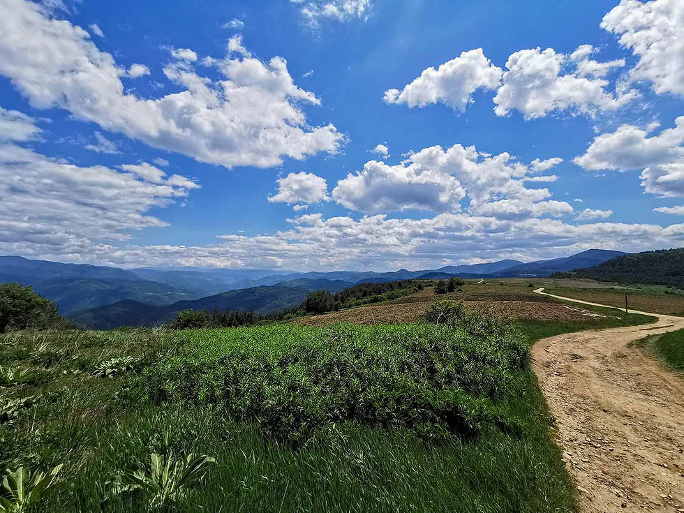
Batak is located in the middle of the Western Rhodopes, at an altitude of 1036 meters above sea level in the valley of the Stara Reka river on both its banks.

Here is the picturesque description of the Old River valley and the Batak settlement through the eyes of the American Januarius (Jan) Aloysius McGahan, a journalist and specialist war correspondent for the London Daily News, on his first visit here weeks after the suppression of the April Uprising.
After three hours of climbing paths so steep that we were obliged to dismount and walk half the time, without then seeming quite safe from rolling into some precipice, rising higher and higher, until it seemed that we got into the clouds, at last we emerged from a dense forest into a lovely little valley, which spread before our eyes a rich carpet of verdure. A small stream ran through it, on which a miniature sawmill had been built. The Batak people seem to have traded considerably in timber which they got from the forests of the surrounding mountains, for we afterwards observed a great number of these small mills, and were even told that there were over two hundred in and about the village.
The mill wheels are now silent.
This little valley, with its rich grassy slopes, must have been covered with herds of sheep and cattle.
Not one was in sight.
The beautiful little place was as lonely as a graveyard, or as if no living creature had trod its rich green for years. We climbed the slope to the right, and when we reached the top of the ridge that separated it from the neighboring valley, a beautiful panorama opened before us. The mountains here seemed to extend in a circle, embracing a country about eight or ten miles in diameter, much lower, which was cut up by a great number of deep hollows and ravines, which intersected it in every direction, and seemed to cross and cut each other off without the slightest manifestation of anything like a watershed reference. It looked more like an enlarged picture of the mountains on the moon than anything else I could think of.
Down at the bottom of one of these hollows we could make out a village, which our guide informed us would still take us an hour and a half to reach, although it looked very close indeed. This was the Batak village we were looking for. The hillsides were covered with small fields of wheat and rye that were golden with ripeness. But though the crop was ripe and overripe, though in many places the well-filled ears had broken the rapidly decaying straw that could no longer hold them up, and now lay flat, there was no sign of reapers trying to save them. The fields were as barren as the little valley, and the crops were rotting in the soil. After an hour we approached the village.
The relief is mountainous, with an average altitude of 1500 meters.

The Rhodopes have a transitional location between temperate continental and Mediterranean climates. At the altitude of Batak, the characteristic features of the mountain climate appear.

90% of the vast territory of the municipality is occupied by centuries-old forests (fir, white pine and spruce), and in the areas with a lower altitude they are mixed with beech and oak forests, highland pastures, forest meadows and meadows. In Batashka mountain are located the most valuable massifs of spruce forests in Bulgaria.

Although it is the second largest in the Pazardzhik region, there are only three settlements in the Batak municipality: Batak, which is the municipal center, and the villages of Nova Mahala and Fotinovo.
I had in front of me a valley divinely beautiful with its indescribable bright green emerald carpet. Not a single tree, not a single bush, not a pebble, not a dark point disturbed the harmony of the green color on this clear and smooth, like a lake, plain... The slopes of the surrounding mountains were wooded above, and their sides dotted with large or small groups of boriki , who strolled picturesquely along the green slopes; only on the south side the woods descended quite low.
Ivan Vazov
It is located in a hollow, surrounded on all sides by hills (barda) rising about 100 to 200 meters above its level (Petrovo bardo, Kaneva borica, Tsaryuv komin, Kadino bardo, Saint George, Piskiliva skala, Galagonkata and Buchete), and above them rise the peaks of Batashka mountain, which borders Chepinska river to the west, Dospatska river and Dospat dam to the south, Vacha river to the east, Thracian lowland to the north.

Here is a protected area Batashki snowfield. Not far from the city are some of the highest peaks in the Rhodope Mountains - Batashki Snow (2082 meters), Golyama Syutkya (2185 meters).
Dam "Batak" and resort area Tsigov Chark are located in the Western Rhodopes near Batak. They are an ideal place to relax at any time of the year. The resort itself has an excellent bed base of all categories, with many bars and restaurants. The waters of the dam provide wonderful opportunities for water sports and fishing.

To the south of Batak stretches the vast area of Beglika, which continues to the Kamen Dyal Pass. This is an extremely beautiful area, through which the Beglish River flows and supplies the "Big Beglik" and "Malak Beglik" dams with its water.

Beglika area occupies the so-called Begliška flatness in the central part of the Western Rhodopes with an average altitude of 1700 meters. The picturesque mountain scenery attracts many tourists, and the dams and crystal clear rivers offer great conditions for fishing. The rich game variety of deer, roe deer, grouse, wild boar favors the development of hunting tourism.
The two biosphere reserves are attractive - "Beglika" (together with the "Golyam Beglik" dam) with an area of 415 hectares, overgrown with centuries-old conifers, and "Dupkata" - a natural phenomenon with diverse flora and fauna under the auspices of UNESCO.
The natural conditions are a prerequisite for the development of hunting, fishing, eco and rural tourism, as well as for the treatment of respiratory diseases.

On a territory of 3,600 square kilometers, which covers the Batashka mountain, the Batashka hydropower road stretches. It was opened in 1959 and is a complex hydrotechnical and energy complex. It collects the waters of 150 rivers and streams.

The colossal water cascade includes three large dams and three hydroelectric power stations with a total capacity of 225,000 kilowatts. For the past fifty years, the cascade has produced billions of kilowatt hours of electricity and irrigated thousands of acres of fertile land.

Shiroka Polyana area is located in the northwestern part of the Western Rhodopes.
The prevailing altitude is between 1500 meters and 1700 meters. The characteristic relief of the Rhodopes - alternation of forest massifs with extensive meadows, creates excellent conditions for the formation of good game stocks. On the territory of the locality there are also the dams "Shiroka Polyana" and "Toshkov Chark", offering excellent conditions for fishing and full recreation.
BEC "Batak" is the first underground hydroelectric power plant in Bulgaria. The reservoirs "Batak", "Golyam Beglik" and "Malak Beglik", "Shiroka Polyana" and "Toshkov Chark" are becoming the main tourist locations in the Batash microdistrict, located from north to south and with increasing altitude. They are a favorite spot for keen fishermen.

The climate of Batak is transitional-continental, noticeably influenced by the altitude. Rainfall is 670 to 680 liters per square meter per year. Due to its location, the city is protected from strong winds. The average annual temperature is around 10°C. Winter is relatively warm. During the autumn-winter season, sunny days prevail. A characteristic phenomenon in this area is the south wind, called by the local population the white wind. Winter has heavy snowfalls of up to 63 centimeters in the city and up to 150 centimeters on the surrounding hills. Summers are cool and pleasant, thanks to which Batak and its area are established as an attractive mountain resort.

Ten protected areas with a total area of 1850.4 hectares have been designated. The largest is Batashki Snezhnik with its 1054 hectares.
The natural features (the undisturbed natural environment, diverse landscape, the presence of reserves, natural attractions, water resources, diverse flora and fauna) and the very location of Batak are ideal conditions for the development of tourism in all its forms, as well as for winter and water sports.

The surroundings of Bataski have been inhabited since ancient times, the evidence of this is the discovered archaeological sites: ruins of numerous (nearly twenty) Thracian, Roman, Byzantine and Slavic fortresses, over ten churches and monasteries, Thracian mounds, a Roman bridge, etc.

Due to the lack of historical information, it is difficult to accurately determine the year in which today's Batak arose.

According to some historical monuments and especially according to the living tradition, the first name of the then settlement was Batevo, from brother, or from bate, so named, probably by the refugees themselves who escaped from the enslavers, or by their forcibly Turkified brothers from the villages in the Chepinsk valley. This is evidenced by a manuscript attributed to Pope Methodius Draginov from the 17th century and considered by modern researchers to be a forgery:
...that year, most of the refugees left the country
near the old river they built a new settlement of Batievo.
Asan ojya for cashmere made the poturniaks spoil it
218 churches. And so, by God's grace, they broke down
you bastards Cepina...
A very important testimony that confirms the existence of the settlement is the inscription on the built stone of the fountain at the Krichim monastery "Nativity of the Virgin", on which both the name Batak and the names of the people of Batak, who built the fountain in 1592, are relied upon.

The settlement got its current name during the Ottoman rule. It is assumed that due to the difficulty for the Ottoman enslavers to pronounce the name Batevo, it was changed to Batak (translated from Turkish mud), due to the lake that is located near its northwestern side. A lake, which the peasants called a swamp, and the Turks göl or batak, because the greater part of it was covered with roots intertwined above the water, overgrown with shavar, papur, and grass, where many who did not know the area had fallen with their horses and were sunk to its bottom.

The strategic geographical position of Batak, bisected on both sides of Stara Reka at the foot of the high Rhodope peak Skardak (Batashki Snezhnik), in a hollow surrounded by ancient mountain trees, protected from the north by an impassable swamp, is not accidental. It was here that the first settlers sought protection from the fanatical attacks of the ferocious Ottoman conquerors. In this way, they did not lose their father's traditions, preserved their faith and customs, unlike other settlements in the Rhodopes, which were forcibly assimilated and forced to accept Islam.

The difficult living conditions made Batachians harsh, determined and fearless. Logging became the main livelihood of the population. The ships of the Turkish Empire were built from the quality local wood, trade developed. Batak traders developed their connections with the nearby peoples of the Mediterranean and the western Balkans.
Batak became a force of attraction for many patriots who moved here to preserve their Christian faith.

The desire of the freedom-loving population for independence is growing more and more. Prominent spiritual figures grew up in Batak, such as Abbot Joseph the Builder, who restored the Rila Monastery in its current form, Abbots Kiril and Nikifor, the author of the remarkable "Bulgarian Primer" (1844) Georgi Busilin, and others.
In the minds of Bulgarians, Batak is always associated with the tragic events that took place here during and immediately after the April Uprising of 1876.

When the uprising was suppressed in May 1876, the local people at first surrendered their weapons, but the army of Bashibozus, led by Ahmed aga Barutanlia, subsequently carried out a merciless mass slaughter of the Bulgarians, better known today as the Batash massacre.

Part of the population was besieged in the church "Sveta Nedelya" for days.

The situation inside is dramatic – the lack of water forces the women to dig a well in the ground with their bare hands, which can still be seen today, in order to find water for their children.

Finally, when the temple was captured, all the Christians (about 2000) were slaughtered by the Bashibozus.

Thanks to Batak's glorious self-sacrifice for the liberation of the fatherland, the world learned about Bulgaria and its will for liberation.

Batak's benefactor - Lady Emily Strangford - appeals to the entire British public and Europeans in Constantinople to help the Bulgarians and creates a foundation to raise funds "Bulgarian Present Relief Fund".
Dear friends, I have dedicated a separate and independent post to the life and work of Batak's benefactor, Lady Emily Strangford, which you can read by following this link.

Today, this monument to Lady Emily Strangford stands in the center of Batak town. On the site of the yellow building (now the Lady Strangford Day Care Centre) which can be seen behind the monument, at one time stood the hospital, built with funds from the foundation. Today on the facade of the building on the main street and facing a commemorative plaque has been placed on the monument.
Here was the hospital for Batachians injured in the April Rising of 1876, built with funds from Lady Emily Strangford.
By Decree No. 546 of the Presidium of the National Assembly of September 7, 1964, Batak acquired the status of a city.

The population is mostly made up of Christians.

The oldest church in the city, as well as one of the oldest in the district, is "Sveta Nedelya".

After the massacre of 1876, the church was inactive and turned into an ossuary museum.

In 1912, the foundations of the new church "Assumption of the Blessed Virgin Mary" were laid.

The temple was built according to the project of the Czech architect Josif Schnitter.

Numerous small chapels are scattered around the city.

On April 3, 2011, by special decision St. The Synod of the BOC declares the Bulgarians who died in the Bata massacre as holy new martyrs.

History has preserved many of the names of the martyrs of Batashka - these are the brutally murdered local priests Peter and Neicho, the great martyr Trendafil Toshev Kerelov - burned alive at the stake, the names of some of those killed - Ivan, Ilia and others, written on the memorial wall in the museum in Batak.

Their memory is officially honored on May 17.
The Balinese house in Batak is a historical and architectural cultural monument.

The Church of the Holy Assumption stands in the center of the city.

Batak is among the hundred national tourist sites of the Bulgarian Tourist Union. It is listed under number 38.

Batak Historical Museum is located in the city center.

How to get to Batak City?
Batak is a city in southern Bulgaria. It is located in the Pazardzhik region and is close to the town of Peshtera. The city is the administrative center of Batak Municipality.
Batak stands for:
147 kilometers (about 2 hours and 20 minutes by car) from the capital 58 kilometers (about 1 hour and 09 minutes by car) from the city of Plovdiv 416 kilometers (about 5 hours and 03 minutes by car) from the city of Varna 309 kilometers (about 3 hours and 17 minutes by car) from the city of Burgas
Dear friends, and before I show you what interesting sights you can see nearby, I would like to remind you about the special photo album, which has collected incredible beauty and impressive photo moments just for you, a link to which you will find at the end of the post!
Enjoy it!
What can be visited nearby?
Just less than 2 kilometers northwest of the town of Batak (less than 4 minutes by car) is the Batak Dam and Tsigov Chark resort area.
Just 24 kilometers southwest of the city of Batak (less than 30 minutes by car) is the Golyam Beglik Dam.
Just 33 kilometers south of the town of Batak (less than 42 minutes by car) is the Shiroka Polyana Dam.
Just 42 kilometers south of the city of Batak (less than 55 minutes by car) is a panoramic site overlooking the Dospat Dam.

Just 48 kilometers south of the city of Batak (less than 1 hour and 2 minutes by car) is the Dospat Dam.

Just 15 kilometers west of the town of Batak (less than 18 minutes by car) is the town of Rakitovo, where you can explore the old clock tower.

Only 8 kilometers north of Rakitovo (about 14 minutes by car) is the village of Dorkovo, where you can see the magnificent church "St. Ilia".

Near Dorkovo there is a unique site, representing a gathering of bones from over 30 species of animals in one place - Pliocene Park.


Near the village are the ancient ruins of the "Tsepina" fortress.

Just 27 kilometers west of Batak (about 33 minutes by car) lies the spa capital of the Balkans – Velingrad – blessed and eternal.

Velingrad is a wonderfully beautiful Bulgarian city located in the Chepin Valley in the Western Rhodopes. It was formed in 1948 by the merger of the villages of Ladzhene, Kamenitsa and Chepino.
Velingrad is one of the most cloudless cities in Bulgaria.
Velingrad's real wealth is its water resources - rivers, karst and mineral springs - they are plentiful.
The Velingrad geothermal field is the largest in southern Bulgaria. The mineral springs (more than 80 in number), the mild climate and the beautiful nature are the greatest wealth of the city. Velingrad is one of the largest balneological resorts in Bulgaria and it is no coincidence that it is known as the spa capital of the Balkans.


In Velingrad, you can take a leisurely walk through the wonderfully beautiful Pine Park.


You can enjoy a magnificent walk to the panoramic platform "The Rocks" above Velingrad, from where a wonderful view of the entire area is revealed.


The place is full of beauty and tranquility!
The "Rocks" panoramic platform above Velingrad is a special place where you will find solitude with nature.
Just 15 kilometers northeast of the town of Batak (about 25 minutes by car) is the starting point of the trail leading to Snow White Cave.

Just 15 kilometers north-east of Batak is the town of Peshtera.


Peshtera is another beautiful Bulgarian city with an extremely combative past and I highly recommend a walk here. I will tell you how to get to the panoramic platform above the city, from where a wonderful view of the entire Cave is revealed!

In Peshtera you can visit the fortress "Peristera".

The old sakhat in Peshtera is a place that has preserved a rich history and I heartily advise you to visit it.

Just about 7 kilometers east of Peshtera (about 11 minutes by car) you will find struggling Bratsigovo.

During your stay in Bratsigovo, I recommend you to visit the magnificent church "St. John the Forerunner" and the tallest Orthodox bell tower on the Balkan Peninsula, which is located in the church yard.

Near the church, you will find the small square "Sinjirli Well", shaped and built around the well, where on April 21, 1876, Vasil Petleshkov read the Invocation, the bloody letter and announced the uprising.

Erected in 1976 on the occasion of the 100th anniversary of the great events of the April Epic, the "Apriltsi" Memorial Park in the city of Bratsigovo is a cultural monument of local importance and I invite you to take the time to explore it.

People's community center "Vasil Petleshkov - 1874" is located in the center of the city.

In addition to its heroic past, Bratsigovo is also famous for its incredible rose plantations, which smell divine in the month of May.

Between the village of Rozovo and Bratsigovo, you will find a wonderful roadside rest area with an exceptional panoramic view of the city.

Just 5 kilometers south of Bratsigovo (about 9 minutes by car) you will find the charming, colorful village of Rozovo, next to which is the Chorbanovo dam.

Continuing along the road, you will find the beautiful and peaceful resort of Rozovski vriz.

Several tourist routes start from Rozovski vriz resort, one of which will take you to Garvanova skala.

Continuing from the village of Rozovo on the road to the village of Ravnogor, which is 16 kilometers south of Bratsigovo (about 27 minutes by car), you will enjoy wonderful views, centuries-old forests and fabulous nature.

Several picturesque tourist routes start from the village of Ravnogor, one of which is the path to Bekovi skali.
The Back Rocks route is often combined with the Red Rock trail.

Only 20 kilometers east of Bratsigovo (about 25 minutes by car) is the village of Ustina.
In Ustina, take the Ustina Ecopath to Ustina Waterfall.

Just 23 kilometers east of Bratsigovo (about 31 minutes by car) you will find charming Peruštitsa.
About 2 kilometers before the town is the Red Church, which I invite you to visit.

In Peruštitsa you can explore the Renaissance (Danovo) School.

Next to the school building is the church "St. Archangel Michael".

On a hill southeast of the city rises a monument to the three generations, to which I recommend you take a walk.

Only 12 kilometers northeast of Peruštitsa (about 15 minutes by car) is the village of Parvenets and a beautiful artificial waterfall, which I suggest you visit.

About 15 kilometers south of the village of Hrabrino (about 24 minutes by car) is the charming Sitovski waterfall.

About 3 kilometers east of the village of Hrabrino (about 6 minutes by car) is the village of Izvor, from where the path to Momini skali starts, which I advise you to take.

Only 10 kilometers north of the town of Peruštitsa (about 14 minutes by car) is the town of Stamboliyski, where I highly recommend you to visit the Stamboliyski Eco Park.

Only 7 kilometers north of the town of Peshtera (about 10 minutes by car) is the village of Radilovo.
In Radilovo, I recommend you to visit the village museum, which preserves its rich history.

People of Radilovo closely guard the memory of Lady Emily Strangford – a symbol of humanity, charity, kindness, generosity and love for Bulgarians. A rich exposition dedicated to the life and work of Lady Emily Strangford is arranged in the museum of Radilovo.

Only about 14 kilometers north of Radilovo (about 20 minutes by car) is the city of Pazardzhik, where you will find the garden of the world and the eternal flame of peace.

The Garden of the World and the Eternal Flame of Peace is located next to Svoboda Park-Island in the city of Pazardzhik.

Just 16 kilometers east of the village of Radilovo (about 18 minutes by car) you will find the village of Patalenitsa.
In the village of Patalenitsa, I recommend you to visit the pearl of Patalenica - the buried church "Saint Dimitar".

Near the village stands the wonderful Batkun spiritual monastery "St. St. Peter and Paul", where you will find majestic tranquility and beauty.

In spring, Patalen's phenomenally beautiful lavender fields exude charm and charm against the backdrop of the majestic Rhodopes.

And finally, my dear friends,
you shouldn't miss checking out
the special photo album with moments –
discovered, experienced, filmed and shared with you!


Comments